Activity
Mon
Wed
Fri
Sun
Jul
Aug
Sep
Oct
Nov
Dec
Jan
Feb
Mar
Apr
May
What is this?
Less
More
Memberships
Wilderness Mastery School
25 members • $1/month
26 contributions to Wilderness Mastery School

27d •
Bush bag IFAKs
What do you folks put in your bushcraft bag IFAKs? I’m not looking to have a standard ifak in my bush bag, just something more practical
1 like • 25d
@Patrick Russell this is exactly the kinda list I was hoping to see pat thank you
0 likes • 25d
@Kenneth Berry sorry to hear he remembers the trauma but glad he’s retaining medical and first aid info from it to

27d •
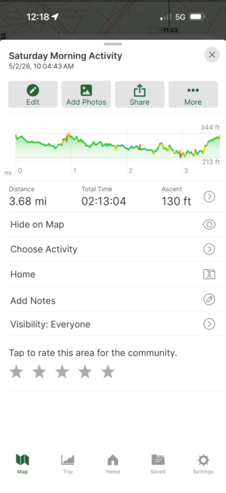
AAR: Saturday / Sunday Overnight 5/2 - 5/3 Personal Challenge
Saturday morning started as planned. I inventoried my Continental Weekender and re-packed it anticipating the over-night. I drove to the conservation area and completed the 3.6 mile hike with the pack. Approximately 25 lbs, with boots, and partially cross country. Two-hours, 13 minutes. I was not unhappy with 1.64 mph especially as I was exploring and collecting resources. I sourced birch bark and Atlantic White Cedar bark all to be dryed out in my hoody pocket and used for a fire that eventing. When I got home, domestically, things completely fell apart. My clothing was quite wet from inside and out, which would have been an issue and a fire would have been essential to dry things out before sleeping. My fire was inside instead of outside and we moved forward. My gear had to be brought in and dried out, although I was extrelely happy with how is survived a wet hike. With just a foam pad and a poncho liner, it would have been a cold night. If I stay with the gathered end hammocks, I should look into a top and bottom quilt. Looking at a couple from OneWind that are not too expensive. All my photos came out in the wrong format. Something else I need to fix.
1 like • 27d
What app do you use for that data? I’ve been contemplating on getting Gaia eventually for offline trail maps but this one looks Nice
0 likes • 25d
@Kenneth Berry excellent I’m glad to hear that
Apr 6 •
Sleeping system
Hey all, Wanted to ask what you could all recommend for a sleeping system, what are the pros/cons between a sleeping bag versus camping blanket, what brand or specifics should I look for when shopping around for one, etc. Thanks in advance
0 likes • Apr 8
@Patrick Russell oh good call, I forgot about those
1 like • Apr 27
@Patrick Russell I’ll Have to check out the local army surplus stores

Feb 25 •
Bow drill
I think I fell upon this site in December. At some point, January had a bow drill fire challenge. Better late than never lol

1 like • Apr 27
I have yet to be able to make one effectively

Apr 23 •
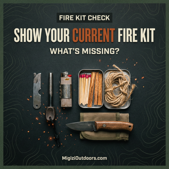
FIRE KIT REALITY CHECK
MISSION:Lay out your current fire kit. STANDARD:Primary + backup ignition. Tinder strategy. Weather consideration. OUTPUT:Photo + short explanation of gaps. REMEMBER:If your fire kit fails, nothing else matters. Prove it.
1 like • Apr 26
@Kenneth Berry me and Chris did that today lol dug a fire hole and did a reverse log cabin style, then we showed his daughter how to forage for birch bark, little sticks, how to use a ferro rod, etc and much more was a fun and productive morning
1 like • Apr 27
One photo has my chest rig, I carry 2 ferro rods with a striker, some waxed rolled cotton plugs, waxed dryer lint, Sasquatch hemp rope, storm matches, and a bic lighter in the rig. The fire striker is inside the orange tube with the smaller ferro rod Second photo I have another ferro rod with a striker, 2 bags of fire plugs, storm matches, fatwood, plastic straws with waxed cotton inside them, and waxed dryer lint.
1-10 of 26

@jon-gouchenouer-3699
Amateur bushcrafter, outdoors lover, father of two
Active 25d ago
Joined Dec 30, 2025
New hampshire