
Write something
Pinned

👑
⭐
10h •
Welcome to Clief Notes. Here's where to start.
1. Go check out 📚Navigating The Course to see how to get around and what's here. 2. Start with The Foundation. Concepts, folder architecture, prompting framework. Everything else builds on this. 3. Check in at the bottom of each lesson. Polls, discussion posts, other members working through the same stuff. Use them. 4. When you're ready to build real things join in on our Biweekly competitions and win some real cash. ⭐ Competitions Mega Thread 5. If you are wanting to dive into the masterminds, grab all the past templates, artifacts and resources. Upgrade and head into the The Vault for Premium and The Drawing Room (VIP) for VIP 6. Post your work. Ask questions. Help others when you can. What are you here to build?
Pinned

1d •
🏆 HOW COMPETITIONS WORK FROM NOW ON 🏆
Quick update on the competition schedule so everyone knows what to expect. 📅 NEW CADENCE: TWICE A MONTH We're dropping comps on the 15th and the 30th of every month. Two chances to compete, every month, on a set schedule you can plan around. ✍️ WHY THIS SCHEDULE Spacing them out this way means we can give tailored feedback on every single submission. Not just the winners. Everyone who enters gets notes on what worked, where it's weak, and what to do next. 🎁 WHAT WINNERS GET Along with the prize, every winner gets a 15-minute one-on-one with Jake. Use it to talk through your build, ask questions, or bring whatever else is on your mind. Two comps a month. Feedback on every entry. Direct time with Jake for the winners. Mark your calendar for the 15th and let's get to work!
Pinned
1d •
🎆 GOOD NEWS: THE SALE STAYS OPEN. HAPPY 4TH 🎆
We're holding the last sale through the holiday weekend so nobody misses it. 🎉 Premium: $27 → $14/mo 🎉 VIP: $97 → $67/mo This is the cheapest it will ever be. Once it closes, the price is gone for good. ⏰ New deadline: July 5th, 10:00 AM EST. This is the last extension. If you've been on the fence, sign up now. You lock this rate in and keep it every month going forward. 🖥️ ONE MORE REASON TO JOIN The week of July 5th we're dropping the software we've been building for this community. It goes out for beta testing first, and only Premium and VIP members get access. Sign up before the sale closes and you're in from day one.

3h •
Agents as Folders.
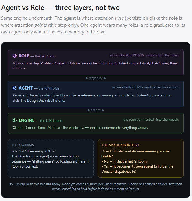
Recently a lot of excellent community discussion around how to ICM. Having experienced rapid growth in my past, one of the hardest things to do is keep language and definitions aligned. If I say the Agent did this, where does your brain go? Lines get crossed because you have so many levels of understanding and perspective. Some people are coming from non-technical backgrounds and have learned through corporate ai marketing. Others coming from corporate environments where language is defined for them by the management and designers building their infrastructure. Mini cultures with their own language. One of the brilliant aspects of ICM is it's commonality with almost anyone on a computer. It's just a folder, from that foundation we can all get on board. What's difficult is what happens next. I had this conversation with claude during a planning session. Claude asked me did I want agents or roles? I responded back by did he mean an agent like claude or codex, which is really an LLM, a purpose built agentic piece of software that the market tells me is an agent that does stuff? Or a folder acting as an agent with a specific role. I didn't know what the underlying meaning implied, how to answer? So I asked here was the response. 1. Engine — the LLM brand (Claude, Codex, Kimi, Minimax). Raw cognition, rented capacity, the electrons. Interchangeable. 2. Agent — the ICM folder. Persistent shaped context: identity + rules + reference + memory + boundaries. A standing operator that exists on disk and endures across sessions. This is your "folders hold attention" — an agent is where attention lives. 1. Role — a lens/hat: a function performed at one step of a process. It exists only in the doing. Where attention points right now.

27m •
I built a 360° drone tour of Roatán — and hit some real engineering walls along the way
Hey everyone 👋 This project was born literally 6 hours ago. I wanted to share something we've been building for our Roatán travel brands: an interactive 360° drone panorama tour of the island — think Google Street View, but flown by drone. Live now (2 locations, more coming): https://roatanquebecois.ca/drone360/ What it is: Fly to a spot on the island, tap around, and you're standing inside a fully navigable 360° sphere — pan, zoom, and jump between locations using bearing-linked arrows and a compass. Right now it's Bitcoin Center and the future hospital site at Dixon Cove, with dozens more planned along the coast. How we did it (the fun part) The drone (DJI Mini 4 Pro) has a "Sphere Panorama" mode that auto-captures ~35 photos in a full rotation. Sounds simple — stitch them together, done. It was not that simple. A few things we had to solve: - True north is a lie from the drone's compass. Steel/rebar near our shoot sites threw the magnetometer 17–23° off. Fix: compute the sun's actual position (azimuth + elevation) for the exact capture time/GPS, find the sun in the photo, and calibrate off that instead. - Ghosting/smear at the seams. Averaging overlapping frames together looked smooth in theory but blurred anything that moved even slightly between shots (parallax). Fix: feature-match every overlapping pair, refine each frame's pose to sub-pixel accuracy, then let ONE frame win at every seam instead of blending them. - Exposure bands in the sky. The drone auto-exposes each of the 35 shots independently — differences up to 50%. That showed up as visible "walls" in the sky at frame boundaries. Fix: solve a per-frame brightness correction across all 35 frames jointly, then a second pass that levels out whatever's left in smooth areas only (so it doesn't smear texture on the ground). - Delivery format. A single flattened image looks fine until you zoom — then it's mush. We switched to tiled, multi-resolution delivery (like Street View uses) so it stays sharp at any zoom level.
1-30 of 2,194

skool.com/cliefnotes
What we give away free beats most paid courses. Build durable AI systems with a Marine vet and Edinburgh researcher. 40+ lessons, growing.
Leaderboard (30-day)
1

🔥
+1698
2

🔥
+1666
3

+1250
4

+972
5

+620
Powered by