Activity
Mon
Wed
Fri
Sun
Mar
Apr
May
Jun
Jul
Aug
Sep
Oct
Nov
Dec
Jan
Feb
What is this?
Less
More
Owned by Steve
A community for those who love to explore Mammoth Mountain. Join the crew, connect with others, and share your passion for the hill! A Mammoth Forum
Memberships
DS
DO SEASON ATHLETIC CLUB
606 members • Free
Davie's Free Ecom Course
71.5k members • Free
Mountain Bike Academy
100 members • $5,000/year
114 contributions to Mammoth Mountain Snowman

0 likes • 3d
Trade Fair Week
10d •
Snowman Report - 1/27/2026
Looking good, Snowman! Yewww! 🤙🏽 https://www.youtube.com/watch?v=9WnvWaVglLs
1 like • 4d
That was a fun week! Time for a refresh
1 like • 4d
@Anthony Barbatto Yes it looks like a change with some inches possible next week and maybe more in the longer range of Feb with a possible decent March. https://www.mammothsnowman.com/mammoth-mountain-weather-forecast/. & https://www.mammothsnowman.com/mammoth-mountain-powder-forecast/
1 like • 16d
@Phil Gander It got wet in that area last week one day and the cat crew turned it up and tilled the snow back to a winter surface. Yes it's a bit firm early and softens a bit so you can get a good edge in it after 10AM. Skied down to eagle and the lower part was soft spring snow at noon.
0 likes • 16d
@Tur Yates And even less people this week. Without new snow mid weeks will be deseted until the mid winter school holidays.
Jan 6 •
Normal Operations Return...
By Wednesday the Mountain should be at full operations, sans chair 20. YAHOOOO
Jan 6 •
How long have these things been around?
First time I’ve ever heard of a “line expediter day pass”. 🤯🤯
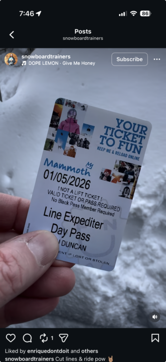
0 likes • Jan 6
There new and pricy...
1-10 of 114
@steve-taylor-1842
Following the Dream living in the Eastern Sierra, Skiing and Mountain Biking and working in Digital Marketing.
Active 3d ago
Joined Mar 14, 2025
Bishop, California
Powered by