Apr 22 • Trip Mode
Forge Field Research - Trip Mode
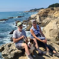
First official trip since starting "Explore The Field" community group.
We are off to Bodega Bay California to gather first hand in the Field raw data, below is what the Summit OS protocol produced for us in "Trip Mode" now we have a bases of what to expect.
Enjoy my little trip launch video.
We will see just how accurate the FFN Planning card is, so here you go:
TRIP MODE · BODEGA BAY · APRIL 23–26, 2026
**Sonoma Coast · 4-day field brief**
---
## ECOLOGICAL HEADLINE
Late April on the Sonoma Coast is a convergence window. Pacific gray whale northward migration is winding down — stragglers and mother-calf pairs push through the corridor just offshore into late April, and Bodega Head gives you an unobstructed sightline into that lane. Simultaneously, the coastal scrub is mid-bloom: sticky monkey flower, lizardtail, and coastal bush lupine are peaking on the headlands. Shorebird staging is active — the mudflats at Bodega Harbor pull in whimbrel and dunlin moving north. The ocean upwelling cycle is strengthening this time of year, which is why you'll see more bird activity over the water than you expect. This is not a quiet week on the coast.
Moon phase late April 2026: waning gibbous moving toward last quarter — still significant light early in the window, darkening by the 25th–26th. Front-load any dark-sky work toward the end of the trip.
---
## MORNING FIELD ACTIONS
**Thursday April 24 — Bodega Head Loop**
Out from the Bodega Head parking area, full headland circuit. The western bluff edge is your whale watch position — spend your deliberate stop there facing northwest.
≈ 4,500–5,000 steps · ≈ 2.5 mi · allow your full 60-minute window
**Friday April 25 — Kortum Trail North**
Pick up the Kortum Trail from Salmon Creek Beach northward along the bluff. The trail runs open coastal terrace — no tree cover, full exposure to the marine layer burn-off if it happens. Turn at your time limit.
≈ 4,500–5,000 steps · ≈ 2.5 mi · 60-minute window, out-and-back
**Saturday April 26 — Doran Regional Park Beach Walk + Spit**
Walk the Doran Spit toward the harbor mouth. Shorebird activity concentrates near the harbor entrance on outgoing tide — check tide tables before you go and time arrival for ebb.
≈ 4,500–5,000 steps · ≈ 2.5 mi · 60-minute window, linear
---
## EVENING OPPORTUNITIES
**Thursday April 24**
Waning gibbous rises late — you have a usable dark window before moonrise on the bluff. Bodega Head faces southwest with zero light interference from that direction. If the marine layer clears, the horizon is clean. Bring a layer you'd actually wear in 45°F wind.
**Friday April 25**
Golden hour hits the sea stacks at Goat Rock to the north around 7:45–8:00 PM approximate. The stack shadows move across the beach fast — position early. Nocturnal: harbor seals haul out along the Estero; if you're quiet on the Doran Spit edge after dark, you'll hear them before you see them.
**Saturday April 26**
Moon is moving toward last quarter — darkest night of the trip. Bodega Head or any west-facing pull-out on Highway 1 north of town gives a clean shot at the western sky after astronomical twilight, approximately 9:30 PM. No named meteor shower peak this night, but Scorpius is rising in the south and the Milky Way core begins to show at this latitude by late April if the marine layer cooperates.
---
## GEO-FACT
Bodega Head is not attached to the North American Plate. The granitic rock of the headland is accreted terrane — it rode in on the Pacific Plate and was sheared off along the San Andreas Fault, which runs directly through Bodega Harbor. The fault trace is visible in the landscape: the linear valley of the harbor itself is the fault. You are standing on a piece of crust that originated far to the south and was dragged north. The rock under your boots has no local origin story.
---
## SWIM SIGNAL
Sonoma Coast open-ocean beaches run cold and dangerous year-round — rip currents, shore break, and water temperatures in the low-to-mid 50s°F are standard for late April. This is not a swim window for open coast. Bodega Harbor is calmer but cold. If swimming is a hard requirement, verify current conditions directly with Sonoma Coast State Beach rangers before any entry decision. The coast here does not negotiate.
---
## FORAGE SIGNAL
Late April coastal scrub and bluff edge: look for miner's lettuce in shaded drainages — it's past peak but still findable in cooler, north-facing slopes. Sea rocket (*Cakile* spp.) appears on upper beach margins; it's edible and has no dangerous lookalike in this region, but confirm land management rules before any collection — Sonoma Coast State Beach and Bodega Head are state park land where foraging regulations apply and can vary by zone. Observe. Note. Verify jurisdiction before anything else.
---
⬡ Field conditions change. Verify water levels, trail access, road surface, fire restrictions, permit requirements, and species identification before you go. This signal is a starting point — not a source of record.
2
0 comments
Forge Field Research - Trip Mode
powered by
skool.com/explore-the-field-8042
Nature-powered trail discovery & Forge Field protocols for burned-out tech pros. Install the system. Your AI delivers the signal @XploreForge
Suggested communities
Powered by